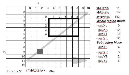
The SubRegion mode
As the model require a considerable period of time to execute on a region large enought to catch the eterogeneyty of agricultural systems, rought calibration can be performed on a sub region, controlled with the parameters subRegionMode, subRegionXLeft, subRegionXRight, subRegionYTop and subRegionYBottom within the main or scenario setting sheet.
If the subRegionMode has been activated, all plots outside its boundaries will be “blanked” for all layers and the agent moulds will be rescaled to fit the sub region dimension. It is important to notice however that the upscaling procedure is made only for the whole region, so it is in the user knowledge to search for a sub region that has similar characteristics (scaled down) of the whole region.
Output of spatial data
Binary data (images) are printed with reference to the sub region only, while grid ASCII data include the whole region. This because they are usefull within a GIS that can georeferentiate correctly the subregion, allowing eventually confrontation between several of them.
Grid Indices
Pixel IDs advance from left to right, from top to bottom, starting from (0,0) like shown in the following figure:
